Sequoia / Kings Canyon National Parks.
One day in Disneyland and 3 days in the forest.
Had planned to leave on Monday, Labor Day. Decided it would be nice to spend all day up in the mountains on Monday. We knew the park would be full, but we can camp anywhere with our FWC. Figured everyone would be up there and we would just drive in and head for dispersed camping in the national forest. We were wrong. Took us an hour to move 2 miles to get to the south gate of Sequoia National Park.

This was the traffic going into the park.

And this is what it looked like behind us.
After we got through the gate the traffic got better and we stopped at the Foothill Visitor's Center. Asked about areas for dispersed camping and found we should not have a problem. They showed all of the major campgrounds full. I had never entered in the south gate, it was a steep climb up the hill and traffic slowed again.

You can see the road we came up starting top left in the canyon. Road is back in view left center just above the rock and winds it's ways up the hill until it goes over in the top right of this picture.
Took this pictures at the top of Moro Rock, more about the rock later.
At every major attraction we came up on, the traffic slowed. At the Giant Forest Museum it started to look like a crowd at Disneyland. See video below, huge line of people waiting for the shuttle bus.
We headed up the road towards Big Meadow, where we had planned to camp. The Park Ranger told us to check at the campgrounds as there might be spots available. We pulled into Dorst Creek Campground and found they had spots. Sounded good to us so we spent the first night there.

Our camp for the night. Most of the campers here were in tents.

Cooking dinner on our Fold and Go grill.

Turkey burgers and a baked potato.


Veronica added green beans and we had a great meal.
The night was quiet and we decided to drive up to Kings Canyon for our Monday tour. The generals highway is one of the few roads that run north and south on the western side of the Sierra's at a high altitude. Stopped at several overlooks, need to come back on a clear, day as smog covered the valley.

All the traffic was headed out of the park on this last day of the Labor Day weekend.

We stopped at Grant's tree on the way to Kings Canyon. The crowds were a fraction of what they were the day before.


Did the walking tour that took us by Gamlin Cabin. The construction was very heavy, not sure I would want to spend a winter in this cabin.


I had expected Kings Canyon to be like Bryce Canyon, why I don't know. It was more like Zion Canyon where you are on in the bottom of the canyon looking up. The road dropping into the canyon was a fantastic drive. I wish I was on my motorcycle for this part of the trip. As we reached the bottom of the canyon, we were reminded that it was still summer in California. Temperature as 95 degrees and heading up. At this elevation it was not going to cool much at night. We had lunch at roads end and decided to drive back up the hill for a campsite in the higher and cooler elevation.

The road down to Kings Canyon.
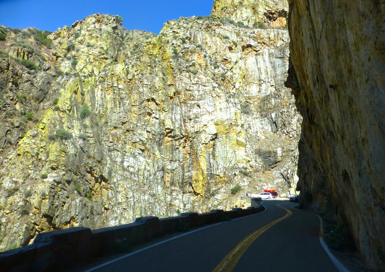
The road was cut into the side of the cliffs. Great views everywhere.


Everything starts to turn green along the river as you reach the bottom of the canyon.
As we drive up the hill we had more great views. You do not want to miss any turns here.


The Kings Canyon Lodge is in National Forest just outside the National Park. They had great signs "Ice Cream Ahead" we stopped for a cold cone in the heat.

They also had two working gravity gas pumps. I did not know any of these were still in use. Five gal. minimum and $6.25 per gallon.
Our camp for the night was the Crystal Springs campground. Yesterday it was full, today there was the camp host, one tent and us.


Even at the high elevation nights were warm. 58 degrees when we got up. Did not need our heater.

Labor Day is a transition weekend for the park. They go from all full to closing 1/2 of the campgrounds. One side of the gate was closed as we left the next morning.

Back into Sequoia National Park for our busy Tuesday. Today was like being in a difference place, 1/10 of the people that were there just two days before. We headed to Crystal Cave and Moro Rock. Two more California Gold locations. I miss Huell Houser.
We stopped and got tickets for the Crystal cave at the Lodgepole Center. 9:30am and they had stopped selling tickets for the 11 am tour. We were told they had to allow 2 hours to get to the cave because of the road work. Bought tickets for the 12 noon tour. We left and waited in line for the 30 min. delay for the road work. Arrived at the cave just before 11am and got on the tour.

The famous spider gate to the cave. This gate was build in the 40's.

Veronica enjoying the view.

Hard to believe how old these are.
After our walk down to the cave we had the walk back up. Walk down was 1/2 mile and 300 feet below the parking lot. Now we had a 1/2 mile walk up 300 feet to the parking lot.

Lots of water still coming down as we walk back up the canyon


We took several breaks walking up the trail to admire the views.

The last set of steps as we get back to the
parking lot.
From the cave we headed over to Moro Rock and lunch. The FWC makes it so easy to find a place to park, pop up the top and make lunch. The DC fridge is dong a great job, don't miss the old propane fridge.


The walk up Moro Rock was only 1/4 mile half of the walk down to the cave. I was however the same 300 feet up. Most of the walk was on steps with a few flat spots in between.

The steps were molded in to the rock.

Stopping to enjoy the view, too bad about the smog in the valley.

The top is in sight.
WE MADE IT.

Short video of the view from the top, we need to come back on a clear day.


This was still our sightseeing day. We passed the turn to Tunnel Log as we drove into Moro Rock and stopped on our way out.

The FWC is low profile, but I backed up to the tunnel to take this picture.
We had a full day of sight seeing and it was time to head to our last campground on this trip. Lodgepole is the parks largest campground. It was completely full on Sunday, today it might have been 1/4 full.

Our camp for the night. You are assigned spots at the larger campgrounds. Park service had all the motorhomes on the other side, we were put with the tent campers. There was only one other truck camper there that night.

Had a steak and potato dinner, finished off with chocolate ice cream. The DC fridge has a small freezer that works just like the one at home.

Our last campfire. Legs were just a little tired as we got ready to enjoy the fire.
Had a great nights sleep in the camper. We both had sore legs when we got up, not used to the hiking up and down the hills. We had one more thing to see before we headed home, the General Sherman Tree. Not the tallest, not the biggest around at the bottom. But it is largest by volume in the world. We parked and found there was another 1/2 mile walk down the hill to the tree.


The Sherman Tree is so big you just can't get it in one picture. As with all the major National Parks you hear a lot of foreign languages. Our National Parks are truly a treasure we all need to get out and enjoy. Not counting the Channel Islands, we have now camped in all the National Parks in California.


Did not see much large wildlife on this trip. Only two dear running in the woods at the Lodgepole Campground. Too far away to get a picture. Did see lots of chipmunks and this white headed woodpecker.

Partway down the trail to the Sherman Tree they have an actual size mosaic of the base of the tree. There is also a nice view of the tree from this spot. See picture below.


You drop out of the hills fast in this part of the Sierras. Lots of orange trees in this part of California. Stopped at a true farmers fruit stand and picked up some fruit to take home with us.
Hope you enjoyed out trip.


